In the weeks since President Biden paused border wall construction, a broad coalition of advocacy groups in Southern Arizona and across the nation wasted no time letting him know exactly where they want him to tear it down.
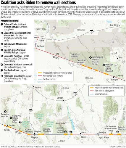
A coalition of nearly 70 environmental groups, civil-rights organizations and tribal entities sent a report last week to lawmakers and Biden administration officials asking for 59 miles of 30-foot-tall border wall in Arizona to be removed, along with sections of wall elsewhere along the U.S.-Mexico border.
Their request came as administration officials are in the middle of a 60-day evaluation of wall projects. Advocates with the No Border Wall coalition hope the report, which focuses on key wildlife corridors, such as the San Pedro River and the Coronado National Forest, will spur officials to adopt a more comprehensive plan for the wall that would include immediately canceling contracts.
People are also reading…
“It’s been so heartbreaking to watch the wall rip across Arizona the last year and a half,” said Laiken Jordahl, borderlands campaigner for the Tucson-based Center for Biological Diversity.
Construction crews started laying the foundation for a 30-foot tall border wall across the San Pedro River in Cochise County. As of July 8, they already built about a half-mile of wall to the east of the river.
“It’s so difficult to pick out specific locations where we feel the wall needs to come down, because the right thing to do would be to tear it down everywhere,” he said.
But at the same time, “we have to be practical and strategic,” he added.
built on federally protected land
The coalition is asking the Biden administration to use the rest of the border wall funds to take down wall sections that block 10 key Arizona wildlife corridors. In all, contractors built more than 220 miles of wall in Arizona.
The border wall is made of 30-foot-tall steel bollards filled with concrete. Each bollard is 6 inches wide and spaced 4 inches apart. It is topped with anti-climbing steel plates. Advocates say the spaces between the bollards won’t allow large animals, such as mountain lions and deer, to cross the border. The wall has some 8.5-inch-by-11-inch openings that allow smaller animals, such as rabbits, to cross.
Some of the sections are small. One of the shortest sections spans 1.8 miles at the San Pedro River in Cochise County. The river area is a regular habitat or migratory stop for nearly half of North America’s bird species including the endangered Mexican spotted owl and southwestern willow flycatcher, according to the coalition’s report. It is also home to an “unmatched” community of more than 90 species of mammals such as the jaguar, ocelot and Mexican gray wolf, and 80 species of reptiles and amphibians.
Before construction began, the only barriers in the roughly 500-foot-wide riverbed were strands of barbed wire and removable vehicle barriers. Now, the 30-foot-tall wall crosses the riverbed and is flanked by a vehicle bridge.

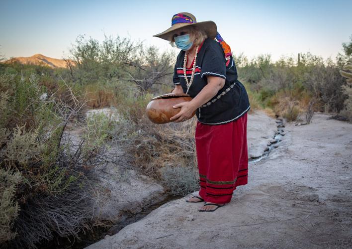
Eleanor Ortega fills a gourd with water from Quitobaquito Springs before a tribal ceremony at Organ Pipe National Monument, on Sept. 27, 2020.
One of the longest wall sections in the report runs along 7 miles of the border near Quitobaquito Springs on Organ Pipe Cactus National Monument. The report describes the area as a sacred place with “deep cultural history” for more than a dozen Native American tribes. Here, the land is “scattered with ancient pottery, shells and other artifacts and features.” For over 8,000 years, people have lived near or traveled to the springs, and prehistoric and historic tribes used the area as a trade route.
The area was a flashpoint during wall construction, with several Tohono O’odham women arrested last year while protesting construction near the springs.
Much of the wall in Arizona was built on federally protected land that wildlife advocates argued should be protected and preserved for future generations. Environmental groups have long raised concerns that the wall would cause ecological damage to wildlife and plant species. They also objected to the Department of Homeland Security waiving laws meant to protect the environment and historical preservation.
Animal migration routes affected
On his first day in office, Biden ordered a halt to border wall construction, as he had pledged to do as a candidate. Earlier this month, he formally rescinded the emergency declaration Trump had used to fund much of the wall construction.
Biden did not address whether he planned to remove sections of wall, although he has called the wall a “waste of money.”
Customs and Border Protection officials said they suspended wall construction, aside from safety-related activities, during Biden’s 60-day assessment period. They did not address specific questions from the Arizona Daily Star about the coalition’s proposal to take down sections of wall.
Last October, Border Patrol officials told the Star the wall will slow down people trying to cross the border illegally, which gives agents more time to respond to remote areas.
The wall also will make it easier for agents to keep track of illicit activity at the border line and free up more time for them to patrol larger areas, Border Patrol officials said.
But wildlife advocates worry the wall is making matters worse for threatened and endangered species in Southern Arizona. In January, a rare jaguar and ocelot were spotted in the borderlands. Due to their habitats extending to both sides of the border, the 30-foot-tall bollards could completely cut off migration routes for the big cats, along with other endangered species like the Sonoran pronghorn and peninsular bighorn sheep, advocates said.
Some sections of the border wall in Arizona “create a significant environmental impact” by interfering with wildlife migration and disturbing crucial bodies of water and wetlands, according to Myles Traphagen, borderlands program coordinator for Wildlands Network.
Animals like jaguars “depend on roaming freely through the landscape for their very survival,” Jordahl said. “In many of these locations, if the wall doesn’t come down, that will be pushing these species closer and closer to extinction.”
The Arizona borderlands serve as a pathway between north and south, a “mixing pot” of tropical ecosystems of Central America with North America’s temperate environment, according to Emily Burns, program director at Sky Island Alliance.
She worries that road construction and lighting infrastructure in the wall projects will disrupt wildlife habitats and migratory patterns.
Advocates call for swift action
Burns hopes lawmakers and administration officials “can fall in love with these amazing places on the border as we have. Then they’ll be eager and interested to invest in restoration that will benefit our communities, that will benefit our natural and cultural resources,” she said.
Rather than a “desert wasteland” as some may picture it, the region is one of the most biodiverse in North America, said Traphagen.
The report justifies wall removal priorities by describing the “vibrant” and “beautiful” landscapes and communities along Arizona’s border, as well as sections in California, New Mexico and Texas.

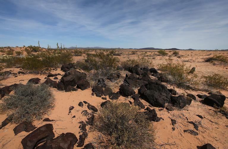
The Sonoran desert landscape consists of volcanic rock and fine sand at points along El Camino del Diablo on the Cabeza Prieta National Wildlife Refuge southwest of Ajo, Ariz., in 2016.
Two priority areas cover about 11 miles of border on the Cabeza Prieta National Wildlife Refuge in Yuma County. They include Las Playas, one of the few remaining natural water sources in the region, and Pinta Sands, part of El Gran Desierto de Altar, the largest active dune system on the continent, according to the report.
“In the middle of the hot, dry desert lies Las Playas, a group of dry lake beds with no drainage outlets,” advocates wrote in the report. “When the rare rain falls in the central part of Cabeza Prieta, it flows into the ephemeral lakes, located next to the international boundary. When the playas are wet, the flora and fauna come to life and the playas become islands of emerald green.”
The report requests stopping construction on a 4.5-mile segment near the Arizona-New Mexico border, where the Peloncillo Mountains “create a biological bridge” between the Sierra Madres and Rocky Mountains.
The coalition is seeking immediate action to restore ecologically fragile areas that have been affected. They plan to release a follow-up report in the coming weeks to assess the most severely damaged areas for restabilization, erosion control and restoration, Traphagen said.
“With the monsoon season only four or five months away, swift action is needed to stabilize these sites in order to prevent catastrophic flood damage when strong summer storms arrive,” he said.
Photos of the U.S. – Mexico border fence
U.S. – Mexico border near Douglas, Ariz.

A dog stands on a road commonly used by Border Patrol near Slaughter Ranch Museum Thursday, Sept. 27, 2019.
U.S. – Mexico border near Douglas, Ariz.
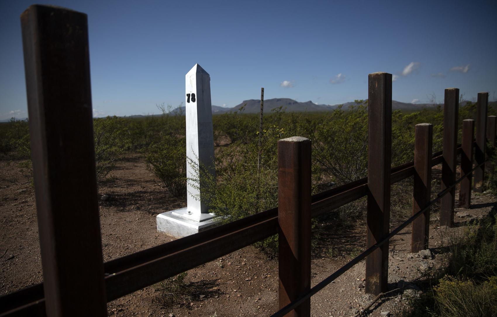
A border monument on the Mexico side of the border seen east of Douglas Thursday, Sept. 27, 2019.
U.S. – Mexico border near Douglas, Ariz.

The San Bernardino National Wildlife Refuge sits on the U.S. side of the border with Mexico east of Douglas Thursday, Sept. 27, 2019.
U.S. – Mexico border near Douglas, Ariz.

A bull and cow graze near the site of new wall construction east of Douglas Thursday, Sept. 27, 2019.
U.S. – Mexico border near Douglas, Ariz.

The border seen stretching from hills east of Douglas into the Guadalupe Mountains Thursday, Sept. 27, 2019.
U.S. – Mexico border near Douglas, Ariz.

Flowers grow around border fencing near the San Bernardino National Wildlife Refuge Thursday, Sept. 27, 2019.
U.S. – Mexico border near Douglas, Ariz.

Construction equipment set up at the site of new border wall construction on the US/Mexico border east of Douglas Thursday, Sept. 27, 2019.
U.S. – Mexico border near Douglas, Ariz.

A Border Patrol tower on the hills east of Douglas Thursday, Sept. 27, 2019.
U.S. – Mexico border near Douglas, Ariz.

Memorials place on graves at Julia Page Memorial Park in Douglas which sits along the U.S./Mexico border Thursday, Sept. 27, 2019.
U.S. – Mexico border near Douglas, Ariz.

A car drives through Douglas on a road parallel to the U.S./Mexico border wall Thursday, Sept. 27, 2019.
U.S. – Mexico border near Douglas, Ariz.

The Slaughter Ranch homestead Thursday, Sept. 27, 2019.
U.S. – Mexico border near Douglas, Ariz.

A lake on the Slaughter Ranch Thursday, Sept. 27, 2019.
U.S. – Mexico border near Douglas, Ariz.

A toy rocking horse placed on the side of East Geronimo Trail with a sign advertising five minute pony rides for 25 cents Thursday, Sept. 27, 2019.
U.S. – Mexico border near Douglas, Ariz.

Highway 2 in Mexico winds its way to Agua Prieta Thursday, Sept. 27, 2019.
U.S. – Mexico border near Douglas, Ariz.

The vehicle in a ditch was driven through the international border fence in Agua Prieta, Mex., into Douglas, Arizona in July 1987.
U.S. – Mexico border near Douglas, Ariz.

Mexican citizens run back into Agua Prieta, Mexico through a hole in the border fence at Douglas, Ariz., after the U.S. Border Patrol scared them back across the border in 1997.
U.S. – Mexico border near Douglas, Ariz.

The Raul Hector Castro Port of Entry on May 1, 2018, in Douglas, Ariz.
U.S. – Mexico border near Douglas, Ariz.

The Douglas, Ariz., border crossing in 1968.
U.S. – Mexico border near Lochiel, Ariz.

U.S./Mexico border fencing next to a old church building in Lochiel Tuesday, Oct. 1, 2019.
U.S. – Mexico border near Lochiel, Ariz.

Old border posts line the U.S./Mexico line near Lochiel Tuesday, Oct. 1, 2019.
U.S. – Mexico border near Lochiel, Ariz.

A Soal Off Roading sticker placed on a U.S./Mexico border post near Lochiel Tuesday, Oct. 1, 2019.
U.S. – Mexico border near Lochiel, Ariz.

Mountains in Santa Cruz County seen from Duquesne Road between Nogales and Lochiel seen Tuesday, Oct. 1, 2019.
U.S. – Mexico border near Lochiel, Ariz.
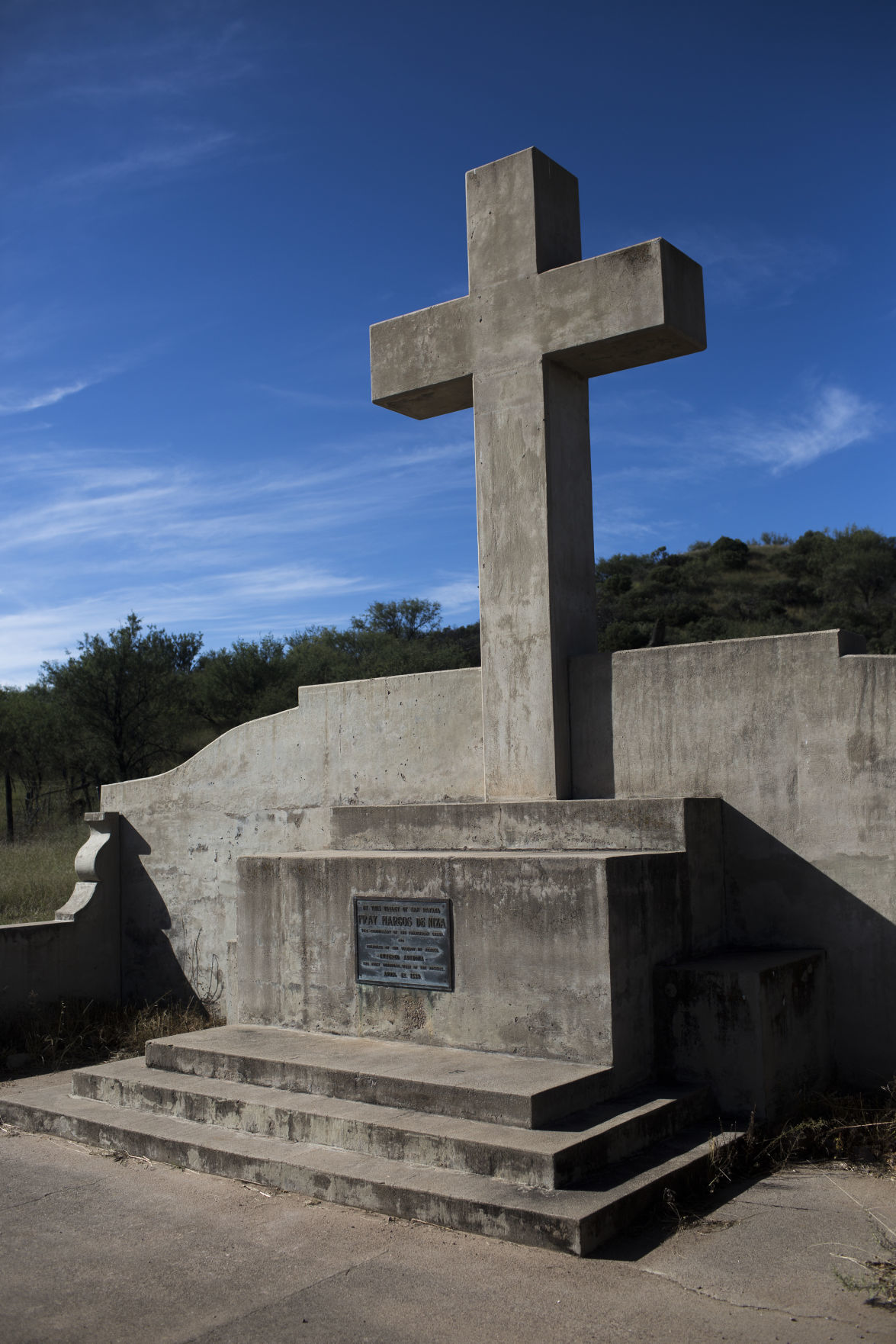
A monument in Lochiel marking where Fray Marcos De Niza entered Arizona Tuesday, Oct. 1, 2019.Tuesday, Oct. 1, 2019.
U.S. – Mexico border near Lochiel, Ariz.

Brothers Ramon and Ed De La Ossa mend fencing on their family's ranch in Lochiel after moving cattle Tuesday, Oct. 1, 2019. The ranch which used to span both sides of the U.S./Mexico border has been in the family for three generations.
U.S. – Mexico border near Lochiel, Ariz.

Ed De La Ossa mends fencing on his family's ranch in Lochiel Tuesday, Oct. 1, 2019. The ranch which used to span both sides of the U.S./Mexico border has been in the family for three generations.
U.S. – Mexico border near Lochiel, Ariz.

Ed De La Ossa moves cattle on his family's ranch in Lochiel Tuesday, Oct. 1, 2019.
U.S. – Mexico border near Lochiel, Ariz.

U.S. Customs inspector Helen Mills, right, greets Mexican counterpart Raymundo Aguirre Castillo at the U.S. - Mexican border station at Lochiel, Ariz., in 1979.
U.S. – Mexico border near Lochiel, Ariz.

The US Customs building, right, at Lochiel, Ariz., is just a short distance away from the international border in May 1972. For ten years, Mills has been managing the port of entry, which is mostly made up of five houses, a school and an vacant church, inspecting vehicles as they head into the US. During the week, from Monday through Saturday, Mills opens the border gate from 8 am to 10 am and from 4 pm to 6 pm. On Sunday the gate is open from 8 am to 6 pm. In that time barely a dozen vehicles make their way across the border but it is a major convenience to the local residents.
U.S. – Mexico border near Nogales, Ariz.

Pedestrians walk to the Nogales port of entry Tuesday, Oct. 1, 2019.
U.S. – Mexico border near Nogales, Ariz.

A pedestrian walks across North Grand Avenue in Nogales near the U.S./Mexico port of entries Tuesday, Oct. 1, 2019.
U.S. – Mexico border near Nogales, Ariz.

U.S. Customs and Border Protection officer R. Hernandez uses a density-measuring device on the rear quarter-panel of a Mexico-bound passenger vehicle at the DeConcini Port of Entry on Nov. 2, 2016, in Nogales, Ariz.
U.S. – Mexico border near Nogales, Ariz.

A Customs and Border Protection officer makes a visual check of a man's identification at the DeConcini Port of Entry on Feb. 15, 2017, in Nogales, Ariz. Busts of fraudulent border-crossing documents and the use of someone else's documents plummeted in Arizona and the rest of the border in the past decade.
U.S. – Mexico border near Nogales, Ariz.

Northbound commercial truck traffic lined up for inspection at the Mariposa Port of Entry on March 28, 2017, in Nogales, Ariz.
U.S. – Mexico border near Nogales, Ariz.

In the commercial lanes a semi truck stops between the lanes looking for the first available opening at the Mariposa Port of Entry in 2015.
U.S. – Mexico border near Nogales, Ariz.

Javier Castillo inspects a north-bound Mexican tractor-trailer at the Arizona Department of Transportation's inspection facility at the Mariposa Port of Entry on Sept. 19, 2017, in Nogales, Ariz. ADOT's International Border Inspection Qualification program, led by ADOT's Border Liaison Unit, teaches commercial truck drivers what to expect during safety inspections when they enter Arizona ports of entry.
U.S. – Mexico border near Nogales, Ariz.

A Border Patrol truck parked near the commercial port of entry in Nogales.
U.S. – Mexico border near Nogales, Ariz.

An illegal alien scales the U.S.-Mexico fence back toward Sonora after a Nogales Police Department officer, right, spotted him west of the Mariposa Port of Entry, Nov. 15, 2018, in Nogales, Ariz.
U.S. – Mexico border near Nogales, Ariz.

Kory's, a store catering to wedding, quincea–era and formal gowns, located at 15 N Morley Ave, Nogales, Ariz., sits katty corner to the Morley Gate Border Station on January 30, 2019.
U.S. – Mexico border near Nogales, Ariz.

Sun shines through the U.S.-Mexico bollard fence west of the Mariposa Port of Entry, Nov. 15, 2018, in Nogales, Ariz.
U.S. – Mexico border near Nogales, Ariz.

Children from Nogales, Sonora, climb through a hole in the international border fence to trick-or-treat in Nogales, Arizona, on Halloween in 1987.
U.S. – Mexico border near Sasabe and Lukeville, Ariz.

Border monument #166 is seen on the right as construction continues on the new 30-foot tall bollard fence that replaces old U.S./Mexico border fence two miles east of the Lukeville, Arizona port of entry on October 8, 2019. Photo taken from Sonoyta, Sonora, Mexico.
U.S. – Mexico border near Sasabe and Lukeville, Ariz.

Construction continues on the new 30-foot tall bollard fence along the U.S./Mexico border two miles east of the Lukeville, Arizona port of entry on October 8, 2019. Photo taken from Sonoyta, Sonora, Mexico.
U.S. – Mexico border near Sasabe and Lukeville, Ariz.

A Mexican worker rides his horse along a road south of the U.S./Mexican border wall on his way back into Sonoyta Wednesday, Aug. 28, 2019.
U.S. – Mexico border near Sasabe and Lukeville, Ariz.

New paneling of border wall seen about three miles east of the Lukeville/Sonoyta port of entry seen from the Mexico side of the border line Wednesday, Aug. 28, 2019.
U.S. – Mexico border near Sasabe and Lukeville, Ariz.

Old mesh paneling is removed in preparation for new wall to be built about three miles east of the Lukeville/Sonoyta port of entry seen from the Mexico side of the border line Wednesday, Aug. 28, 2019.
U.S. – Mexico border near Sasabe and Lukeville, Ariz.

A construction worker prepares cables to lift a piece of the 30-foot tall bollard fence along the U.S./Mexico border fence two miles east of the Lukeville, Arizona port of entry on October 8, 2019. Photo taken from Sonoyta, Sonora, Mexico.
U.S. – Mexico border near Sasabe and Lukeville, Ariz.

Border Patrol Officers to the side of a worksite about three miles east of the Lukeville/Sonoyta port of entry where new border wall is being installed seen from the Mexico side of the border line Wednesday, Aug. 28, 2019.
U.S. – Mexico border near Sasabe and Lukeville, Ariz.

Old wall east of the Lukeville/Sonoyta port of entry seen from the Mexico side of the border line Wednesday, Aug. 28, 2019.
U.S. – Mexico border near Sasabe and Lukeville, Ariz.

Raised wall east of the Lukeville/Sonoyta port of entry seen from the Mexico side of the border line Wednesday, Aug. 28, 2019.
U.S. – Mexico border near Sasabe and Lukeville, Ariz.

A work site east of the Lukeville/Sonoyta port of entry seen from the Mexico side of the border line Wednesday, Aug. 28, 2019.
U.S. – Mexico border near Sasabe and Lukeville, Ariz.

Normandy fencing placed against a section of border fence west of Lukeville Wednesday, Aug. 28, 2019.
U.S. – Mexico border near Sasabe and Lukeville, Ariz.

A semi passes by Quitobaquito Springs as it drives along Highway 2 in Mexico Wednesday, Aug. 28, 2019.
U.S. – Mexico border near Sasabe and Lukeville, Ariz.

An area referred to as "flood gate" along the U.S./Mexico border near Sasabe, Ariz. is on the list of the Department of Homeland Security’s priorities for building a border wall, but no funding has been allocated yet. September 16, 2019.
U.S. – Mexico border near Sasabe and Lukeville, Ariz.

Vehicle barriers mark the U.S./Mexico border within the Buenos Aires National Wildlife Refuge in Sasabe, Ariz. on September 16, 2019.
U.S. – Mexico border near Sasabe and Lukeville, Ariz.

A portion of the U.S./Mexico bollard border fence ends on the right and vehicle barriers begin within the Buenos Aires National Wildlife Refuge in Sasabe, Ariz. on September 16, 2019.
U.S. – Mexico border near Sasabe and Lukeville, Ariz.

A U.S. Customs and Border Protection Integrated Fixed Tower, left, near Sasabe, Ariz. on September 16, 2019.
U.S. – Mexico border near Sasabe and Lukeville, Ariz.

The new 30-foot tall bollard fence that replaced old U.S./Mexico border fence can be seen on the left. It's located about miles east of the Lukeville, Arizona port of entry on October 8, 2019. Photo taken from Sonoyta, Sonora, Mexico.
U.S. – Mexico border near San Luis, Ariz.

A US Border Patrol vehicle seen next to a section of new 30 foot high wall along the US/Mexico border near the commercial port of entry in San Luis Thursday, Aug. 8, 2019.
U.S. – Mexico border near San Luis, Ariz.

Old fencing is taken down along the United States/Mexico border seen from the northern end of San Luis, Mexico, Aug. 7, 2019.
U.S. – Mexico border near San Luis, Ariz.

A security guard stand in a construction site where a new fence will be placed on the United States/Mexico border seen from the northern end of San Luis, Mexico, Aug. 7, 2019.
U.S. – Mexico border near San Luis, Ariz.

Old fencing against new fencing along the United States/Mexico border seen from the northern end of San Luis, Mexico on Aug. 7, 2019.
U.S. – Mexico border near San Luis, Ariz.

Crews prepare ground for a new fence to be placed on the United States/Mexico border seen from the northern end of San Luis, Mexico on Aug. 7, 2019.
U.S. – Mexico border near San Luis, Ariz.

Vehicles in line to enter the United States from San Luis, Mexico on Aug. 7, 2019.
U.S. – Mexico border near San Luis, Ariz.

New fencing along the United States/Mexico border seen from the northern end of San Luis, Mexico on Aug. 7, 2019.
U.S. – Mexico border near San Luis, Ariz.

A new section of fencing on the U.S. - Mexico border in California, just west of Yuma, Ariz., in 1993.
U.S. – Mexico border near San Luis, Ariz.

Sand drifts through the "floating fence" that marks the border running through the dunes, Wednesday, July 25, 2018, west of San Luis, Ariz.
U.S. – Mexico border near San Luis, Ariz.

A sign warns of the dangers of trying to swim the All-American Canal just north of the Mexican border, Wednesday, July 25, 2018, west of San Luis, Ariz.
U.S. – Mexico border near San Luis, Ariz.

A long string of lights illuminate the no-man's land between the triple fencing of the Mexican border, Wednesday, July 25, 2018, San Luis, Ariz.
U.S. – Mexico border near San Luis, Ariz.

The border fence comes to an abrupt end at the currently dry Colorado River, Thursday, July 26, 2018, west of San Luis Rio Colorado, Sonora.
Star reporter Curt Prendergast contributed to the story.
Mandy Loader is a graduate student at the University of Arizona School of Journalism and an apprentice at the Star. You can reach her at starapprentice@tucson.com.